Milky Way over Devils Tower

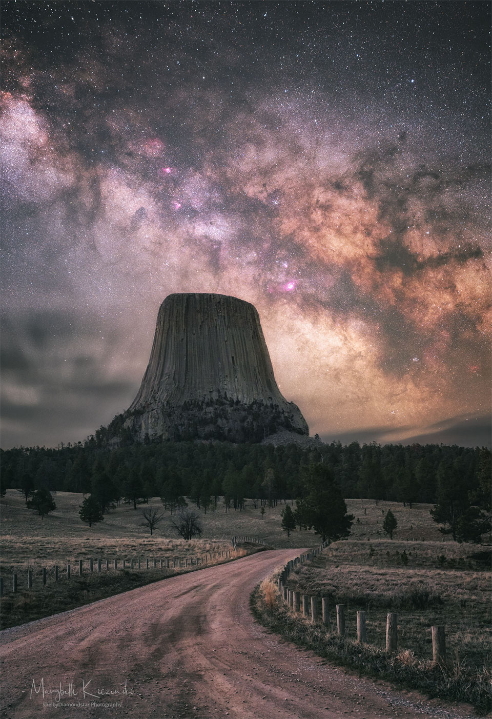
What created Devils Tower? The origin of this extraordinary rock monolith in Wyoming, USA is still debated, with a leading hypothesis holding that it is a hardened lava plume that never reached the surface to become a volcano. In this theory, the lighter rock that once surrounded the dense volcanic neck has now eroded away, leaving the dramatic tower. Known by Native Americans by names including Bear’s Lodge and Great Gray Horn, the dense rock includes the longest hexagonal columns known, some over 180-meters tall. High above, the central band of the Milky Way galaxy arches across the sky. Many notable sky objects are visible, including dark strands of the Pipe Nebula and the reddish Lagoon Nebula to the tower’s right. Green grass and trees line the foreground, while clouds appear near the horizon to the tower’s left. Unlike many other international landmarks, mountaineers are permitted to climb Devils Tower. via NASA https://ift.tt/HOlTXML

N11: Star Clouds of the LMC

Massive stars, abrasive winds, mountains of dust, and energetic light sculpt one of the largest and most picturesque regions of star formation in the Local Group of Galaxies. Known as N11, the region is visible on the upper right of many images of its home galaxy, the Milky Way neighbor known as the Large Magellanic Cloud (LMC). The featured image was taken for scientific purposes by the Hubble Space Telescope and reprocessed for artistry. Although the section imaged above is known as NGC 1763, the entire N11 emission nebula is second in LMC size only to the Tarantula Nebula. Compact globules of dark dust housing emerging young stars are also visible around the image. A recent study of variable stars in the LMC with Hubble has helped to recalibrate the distance scale of the observable universe, but resulted in a slightly different scale than found using the pervasive cosmic microwave background. via NASA https://ift.tt/riEGUJL

When Galaxies Collide

A spectacular head-on collision between two galaxies fueled the unusual triangular-shaped star-birthing frenzy, as captured in this image from Hubble. via NASA https://ift.tt/H7ileRt

NASA to Discuss Plans Today for Artemis Moon Mission Modified Test

NASA will hold a media teleconference at 4 p.m. EDT today, Monday, April 11, to provide an update on the final major test of the agency’s mega Moon rocket and spacecraft on the launch pad at the agency’s Kennedy Space Center in Florida ahead of the uncrewed Artemis I lunar mission.

from NASA https://ift.tt/J3zaryu
via IFTTT

A Space Station Crosses a Busy Sun

Typically, the International Space Station is visible only at night. Slowly drifting across the night sky as it orbits the Earth, the International Space Station (ISS) can be seen as a bright spot several times a year from many locations. The ISS is then visible only just after sunset or just before sunrise because it shines by reflected sunlight — once the ISS enters the Earth’s shadow, it will drop out of sight. The only occasion when the ISS is visible during the day is when it passes right in front of the Sun. Then, it passes so quickly that only cameras taking short exposures can visually freeze the ISS’s silhouette onto the background Sun. The featured picture did exactly that — it is actually a series of images taken earlier this month from Beijing, China with perfect timing. This image series was later combined with separate images taken at nearly the same time but highlighting the texture and activity on the busy Sun. The solar activity included numerous gaseous prominences seen around the edge, highlighted in red, filaments seen against the Sun’s face, and a dark sunspot. via NASA https://ift.tt/LH097GR

Shadows at the Moons South Pole

Was this image of the Moon’s surface taken with a microscope? No — it’s a multi-temporal illumination map made with a wide-angle camera. To create it, the Lunar Reconnaissance Orbiter spacecraft collected 1,700 images over a period of 6 lunar days (6 Earth months), repeatedly covering an area centered on the Moon’s south pole from different angles. The resulting images were stacked to produce the featured map — representing the percentage of time each spot on the surface was illuminated by the Sun. Remaining convincingly in shadow, the floor of the 19-kilometer diameter Shackleton crater is seen near the map’s center. The lunar south pole itself is at about 9 o’clock on the crater’s rim. Crater floors near the lunar south and north poles can remain in permanent shadow, while mountain tops can remain in nearly continuous sunlight. Useful for future outposts, the shadowed crater floors could offer reservoirs of water-ice, while the sunlit mountain tops offer good locations to collect solar power. via NASA https://ift.tt/p6LrAnB

Mars Saturn Conjunction

Fainter stars in the zodiacal constellation Capricornus are scattered near the plane of the ecliptic in this field of view. The two brightest ones at center aren’t stars at all though, but the planets Mars and Saturn. Taken on the morning of April 4, the telescopic snapshot captured their tantalizing close conjunction in a predawn sky, the pair of planets separated by only about 1/3 of a degree. That’s easily less than the apparent width of a Full Moon. Can you tell which planet is which? If you guessed Mars is the redder one , you’d be right. Above Mars, slightly fainter Saturn still shines with a paler yellowish tinge in reflected sunlight. Even at the low magnification, Saturn’s largest and brightest moon Titan can be spotted hugging the planet very closely on the left. via NASA https://ift.tt/9lkbriN